Because we were up early on Tuesday to wash our clothes (we have to run the washing machine when the generator is charging the batteries), we decided to go for a walk around the guesthouse property.
 |
| The sun was just coming up |
 |
|
You can see the limits of the FHM property in this (old) Google Earth shot, with the guesthouse corner in the shadow of the airplane wing. Look for the tan, trapizoidal outline around the property, with the wide road, Route National #2, as the boundary on the left side. Number the corner in the lower left as Corner #1. This is where the guesthouse now stands.
Lower right is Corner #2. Upper right is Corner #3 and the upper left where the shadow and the corner of the FHM property and the road all come together is Corner #4.
The Carrefour (crossroads) Deviation Cassange, part of our address here, is the dominant intersection on the left side of the photo. |

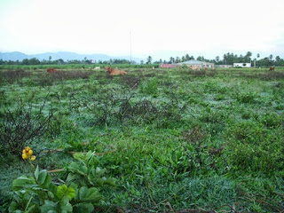
It hadn’t rained, so it was fairly easy to walk without getting our feet wet. Over 50 animals were grazing, mostly dairy cows, a few horses and several calves and foals.
The guesthouse has mountains on two sides. The view above is between the guesthouse, Corner #1, and Corner #2.
The photo below is looking back towards Corner #1 from Corner #2

As we continued our walk, we looked from Corner #2 to Corner #4, across the long diagonal of the 10 acres.

Along the fence line between Corner #3 and Corner #4, there are many banana trees. This is the property line that we share with Yoleine Gateau of M’ Petit Village.

Not sure this was the type of mother and child that the Walmers envisioned when they bought this property for a women’s and children’s health care center

Rounding the last side of the property, along the street, with cleome in the foreground.

By the time we got back to the guesthouse, it was 7 am. The early morning light had faded and the sun was making its presence known.

